


About the Byway
![]()
The Santa Fe Trail Scenic & Historic Byway traverses one of the last strongholds of the nomadic Plains Indians and one of the first toeholds of Anglo-American pioneers, who began homesteading along the Arkansas River in the 1860s. This Colorado Byway follows an 188-mile portion of the original Santa Fe Trail.
The Mountain Branch of the Santa Fe Trail entered what is now Colorado just east of present-day Holly and followed the Arkansas River to Bent’s Old Fort, once a trading post and cultural melting pot, now a National Historic Site. From Bent’s Fort the route traveled along the current US Highways 50 and 350 to Trinidad and crossed Raton Pass, a mountain gap used by Native Americans for centuries.
On a clear spring day, a sharp observer can still discern the wagon-wheel ruts of the Santa Fe Trail wending their way across the prairie. The cultural legacies of this historic trade route, which saw its heaviest use between the 1820s and 1870s, remain just as distinct.
The Santa Fe Trail was designated by the U.S. Secretary of Transportation as a National Scenic Byway in 1998. It is one of 13 America’s Byways® designated in Colorado.
Features and Attractions on a Byway Tour
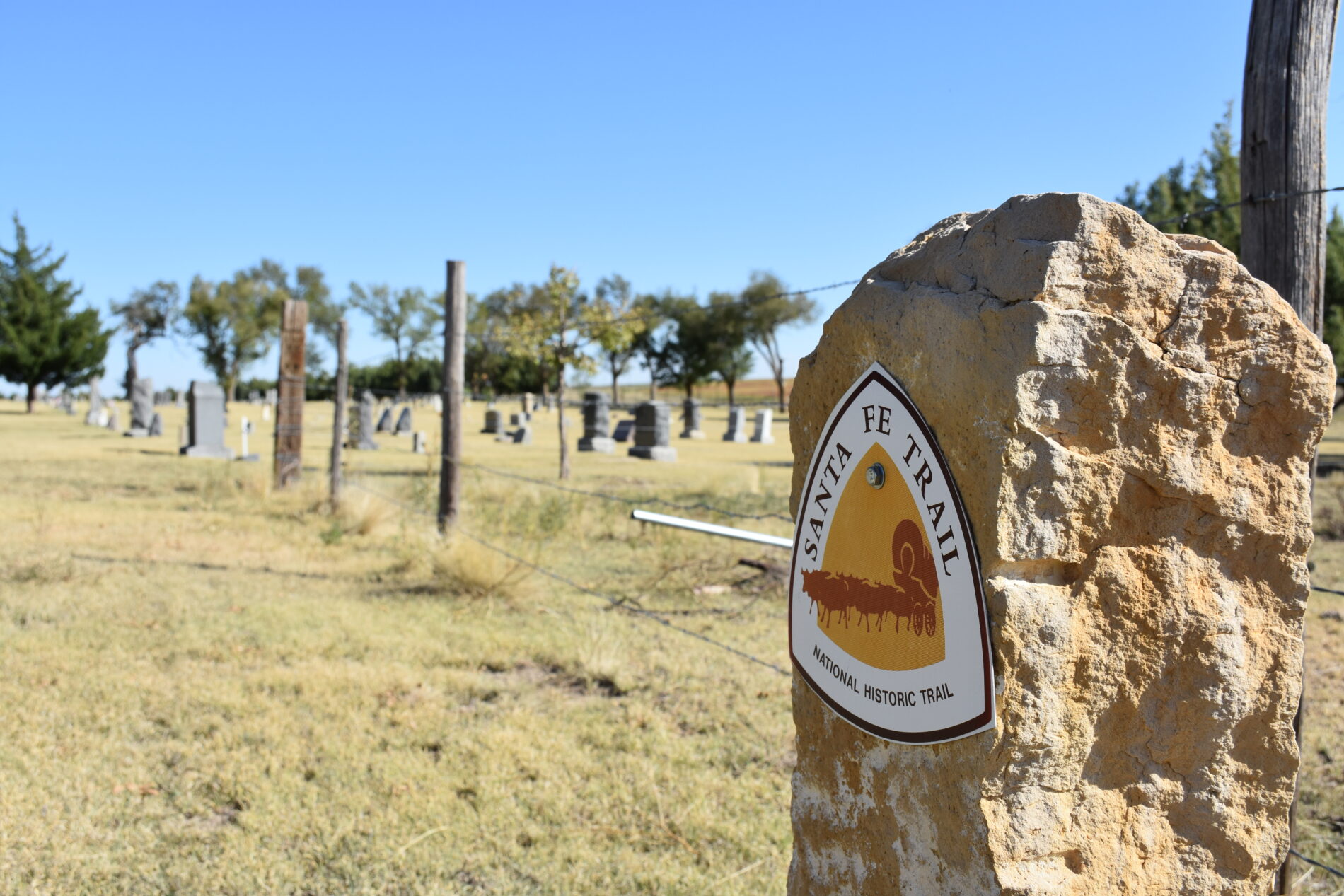
As you enter Colorado, the first town you come to, Holly, offers the first chance to see ruts of the Santa Fe Trail. They are at the entrance to the Holly Cemetery, located just north of US Highway 50 off of County Road 35. The ruts are marked just as you enter the cemetery gates. The cemetery also has a monument to and the graves of the victims of the Towner Bus Tragedy when several children perished after their school bus got stranded in a terrible blizzard in 1931.
Next, learn about controversial American history with a detour to two National Park Service sites: Amache National Historic Site just west of Granada and Sand Creek Massacre National Historic Site to the north. Amache is the former site of a World War II incarceration camp known as Camp Amache or the Granada Relocation Center, which housed more than 7,000 Japanese-Americans, most of whom were U.S. citizens at the time. The Sand Creek Massacre site memorializes another atrocity, where U.S. volunteer soldiers viciously attacked a village of Cheyenne and Arapaho Indians in 1864, resulting in 230 American Indian deaths — mostly women, children, and the elderly.
When you arrive in Lamar be sure to visit the Colorado Welcome Center. Here you can see the Madonna of the Trail statue – one of 12 statues erected across the country in the 1920s by the Daughters of the American Revolution dedicated to pioneer women. Then explore town history with visits to Lamar Theatre, a beautiful 1946 art-deco building, and the Big Timbers Museum, which houses a World War I poster collection. Shore Arts Center warrants a stop for its performing arts programming and gallery.
Back on the byway (now U.S. 50 heading west), just past the Prowers County/Bent County line, a turn onto County Road 35 will take you to the site of Bent’s New Fort. This post, built by William Bent after abandoning his original post 40 miles upriver, eventually became the site of the original Fort Lyon, from which troops marched north to attack the village at Sand Creek. Though on private property, the site is open to visitors and includes a short trail with interpretive panels telling the story of the forts.
Continuing west back of U.S. 50, you pass by John Martin Reservoir State Park, the second largest body of water in Colorado. Two rare birds — the piping plover and the interior least tern — can be spotted along the lakeshore in summer. It’s also an official stop on the Plover Trail, part of the network of Colorado Birding Trails. Camping and picnic grounds are available in the state park. The state park also contains a protected area of swales or ruts of the Santa Fe Trail.
Back on U.S. 50, just east of Las Animas, historic Fort Lyon lies a few miles south of the highway on Colorado Highway 183. Established here in 1867, the post protected travelers on the Santa Fe Trail as well as early settlers in the region. Later it became a naval hospital and a correctional facility. Today it serves as a rehabilitation center. Many historic buildings remain. Just inside the entrance gate is the Kit Carson Chapel, a relocated building, once the post surgeon’s office, where Kit took his last breaths.
When you arrive in Las Animas, plan for a stop at Boggsville Historic Site, a restored mid-19th-century settlement remembered as an early Colorado agriculture and trade center. This Santa Fe Trail historic site preserves two historic 1860s buildings, the Boggs and Prowers houses, and was the last home of the famous Kit Carson. The J.W. Rawlings Heritage Center in downtown Las Animas is also worth a visit for insight into the history of this Santa Fe Trail town.
For another extremely worthy detour not to be missed, hop off the byway and follow signs to Bent’s Old Fort National Historic Site. Founded in 1833 by brothers William and Charles Bent and their partner, Ceran St. Vrain, this reconstructed fort was a trading post strategically located between fur trappers in the Rockies, traders on their way to Santa Fe, and Cheyenne, Arapaho, Comanche and Kiowa Indians who hunted in the area. Today, National Park Service rangers in period attire staff the fort and bring the 1840s to life for visitors.
The next major town on the byway, La Junta, is an Official Colorado Main Street Community, is home to the Koshare Museum, opened in 1949 by a group of Boy Scouts inspired by American Indian culture. Amazingly, this small museum houses one of the country’s greatest collections of Native American art by some of the most famous Taos artists. Also in La Junta, the Otero Museum is filled with artifacts related to area history including a stagecoach that traveled the trail. Several relocated buildings here take you back to the region’s early days.
As you head southwest on U.S. 350 through Comanche National Grassland, look closely and you’ll see this area is full of life. Falcons and hawks search for prey, songbirds flit from the grasses and antelope graze in the meadows. In late summer, the roadside is inundated with sunflowers. And the U.S. Forest Service, which manages the grassland, has developed three interpretive sites that focus on the history of the Santa Fe Trail, which parallels U.S. 350 between La Junta and Trinidad. First, Sierra Vista Overlook (about 1/2 mile south of U.S. 350 on Colorado 71) offers a view of the Rockies to the west as well as the start of a 3-mile hiking route where visitors can walk the historic path of the trail to Timpas Picnic Area. Back on U.S. 350, Timpas Picnic Area is located just west of the highway at the tiny town of Timpas. Besides picnic pavilions and a toilet, Timpas offers a short 1/2 mile nature trail that takes you out to a Santa Fe Trail marker near the banks of Timpas Creek. Continuing down U.S. 350, the Iron Springs Historic Site, just east of the highway, offers more hiking opportunities along the historic trail including some of the best swales or ruts to be found in Colorado.
End your tour in Trinidad, a small city with a quaint Victorian downtown. It’s recognized as another Official Colorado Main Street Community and for its historic El Corazón de Trinidad Creative District replete with local artists, artisans and galleries. Stop by the historic Baca House, a grand adobe house that Felipe and Dolores Baca acquired for 22,000 pounds of wool in 1873. On the same site, you can visit Bloom Mansion, another historic home that’s part of the Trinidad History Museum, and the Santa Fe Trail Museum, which displays family heirlooms and commercial goods of the time.
Events on the calendar: Santa Fe Trail Days in Las Animas, Tarantula Fest in La Junta, High Plains Snow Goose Festival in Lamar, Bent’s Old Fort Living History Encampment near La Junta.
Interactive Trail Map
Use the interactive map below to learn more about each point on the Santa Fe Trail. From the menu in the top left-hand corner of the interactive map, choose Layer List. Then, select Fe Santa NHT from the Layer list.
Next, click on the 3 dots to the right and select “Zoom To” from the menu that appears. Then, use the + and – signs in the upper right corner of the map to zoom into or out of the particular area of the Santa Fe Trail you would like to see. This will allow you to Zoom into very detailed topographic maps showing the route of the Trail.